
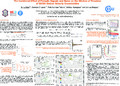
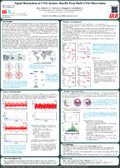
  | ERKIHUNE, E. N., TEFERLE, F. N.* , HUNEGNAW, A.* , & DUMAN, H.*. (14 December 2023). Multi-GNSS Precise Point Positioning with Ambiguity Resolution using IGS Products: A Cross-Evaluation of Three Software Packages and Combinations of Constellation Data for Geophysical Investigations [Poster presentation]. American Geophysical Union (AGU23) Conference. * These authors have contributed equally to this work. |
 | Nurunnabi, A. A. M., & Teferle, F. N. (07 October 2023). Maschinelles Lernen in der automatischen Auswertung von Punktwolken: Beispiele der Erfahrungen an der Universität Luxemburg [Paper presentation]. Kleiner Geodätentag Rheinland-Pfalz, Saarland, Luemburg, Kaiserslautern, Germany. |
 | Rehman, H. U., Teferle, F. N., & Schumann, G. (June 2023). A High-Resolution Numerical Weather Prediction Model for Nowcasting Precipitation in the Grand-Duchy of Luxembourg (NWPLux) [Poster presentation]. International Precipitation Conference (IPC) 14 at Norman , Ok, USA. |
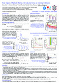
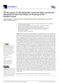 | Hunegnaw, A., Duman, H., Ejigu, Y. G., Baltaci, H., Dousa, J., & Teferle, F. N. (20 January 2023). On the Impact of GPS Multipath Correction Maps and Post-Fit Residuals on Slant Wet Delays for Tracking Severe Weather Events. Atmosphere, 14 (219), 1-26. doi:10.3390/atmos14020219  Peer Reviewed verified by ORBi Peer Reviewed verified by ORBi |
 | Fodor, J., Akbarieh, A., Schäfer, M., & Teferle, F. N. (2023). Sustainability assessment of a novel reusable and demountable steel-concrete composite floor system. In ECPPM 2022 - eWork and eBusiness in Architecture, Engineering and Construction 2022. Norway: CRC Press. Peer reviewed |
 | NURUNNABI, A. A. M., Sadahiro, Y., TEFERLE, F. N., Laefer, D., & Li, J. (2023). DETECTION AND SEGMENTATION OF POLE-LIKE OBJECTS IN MOBILE LASER SCANNING POINT CLOUDS. In DETECTION AND SEGMENTATION OF POLE-LIKE OBJECTS IN MOBILE LASER SCANNING POINT CLOUDS. Cairo, Egypt: ISPRS. doi:10.5194/isprs-archives-XLVIII-1-W2-2023-27-2023 Peer reviewed |
 | Teferle, F. N., Hunegnaw, A., Duman, H., Baltaci, H., Ejigu, Y. G., & Dousa, J. (14 December 2022). On Improving Slant Wet delays for Tracking Severe Weather Events: An evaluation During Two Storms in Europe [Paper presentation]. American Geophysical Union (AGU) Fall Meeting 2022, Chicago, IL, USA, United States. |
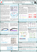
 | Erkihune, E. N., Teferle, F. N., & Hunegnaw, A. (12 December 2022). First Results of the GNSS Reprocessing at the University of Luxembourg for an Updated Global Vertical Land Movement Data Set [Paper presentation]. American Geophysical Union (AGU) Fall Meeting 2022, Chicago, IL, USA, United States. |
 | Teferle, F. N. (10 November 2022). Forschung in Geodäsie und Geoinformation an der Uni.lu [Paper presentation]. Vortragsreihe - Luxembourg Association of Geodesy and Geoinformation (LAGG), Luxembourg, Luxembourg. |
 | Nurunnabi, A. A. M., Teferle, F. N., Balado, J., Chen, M., Poux, F., & Sun, C. (2022). Robust Techniques for Building Footprint Extraction in Aerial Laser Scanning 3D Point Clouds. In Robust Techniques for Building Footprint Extraction in Aerial Laser Scanning 3D Point Clouds. Peer reviewed |
 | Nurunnabi, A. A. M., Teferle, F. N., Laefer, D., Remondino, F., Karas, I. R., & Li, J. (2022). kCV-B: Bootstrap with Cross-Validation for Deep Learning Model Development, Assessment and Selection. In kCV-B: Bootstrap with Cross-Validation for Deep Learning Model Development, Assessment and Selection. ISPRS. doi:10.5194/isprs-archives-XLVIII-4-W3-2022-111-2022 Peer reviewed |
 | Teferle, F. N., Hunegnaw, A., Duman, H., Baltaci, H., Ejigu, J. G., & Dousa, J. (07 July 2022). On the Application of Multipath Stacking Maps for Improved Severe Weather Tracking and Low-cost Antenna Calibration [Paper presentation]. International Summit Forum of Engineering Science and Technology on «Beidou/GNSS Navigation and Location Service in Intelligent Era», Wuhan, China. |
 | Nurunnabi, A. A. M., Teferle, F. N., Lindenbergh, R., Li, J., & Zlatanova, S. (2022). Robust Approach for Urban Road Surface Extraction Using Mobile Laser Scanning Data. In Robust Approach for Urban Road Surface Extraction Using Mobile Laser Scanning Data. Peer reviewed |
 | Nurunnabi, A. A. M., & Teferle, F. N. (2022). Resampling methods for a reliable validation set in deep learning based point cloud classification. In Resampling methods for a reliable validation set in deep learning based point cloud classification. Peer reviewed |
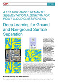 | Nurunnabi, A. A. M., Lindenbergh, R., & Teferle, F. N. (2022). Deep Learning for Ground and Non-ground Surface Separation: A Feature-based Semantic Segmentation Algorithm for Point Cloud Classification. ORBilu-University of Luxembourg. https://orbilu.uni.lu/handle/10993/52284. |
 | Hunegnaw, A., Duman, H., Elgered, G., Dousa, J., & Teferle, F. N. (26 May 2022). Analysis of GNSS sensed slant wet delay during severe weather events in central Europe [Paper presentation]. EGU General Assembly 2022, Vienna, Austria. |
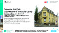 | Teferle, F. N., Wieneke, L., Parvaz, S., Bebon, Q., & Backes, D. (05 May 2022). Scanning the Past: A 3D Model of Trausch's Library [Paper presentation]. Producing Histography in a Changing World - Practices of Historians in Analog and Digital Contexts, Luxembourg and Esch-sur-Alzette, Luxembourg. |
 | Hunegnaw, A., & Teferle, F. N. (28 April 2022). Evaluation of the Multipath Environment Using Electromagnetic-Absorbing Materials at Continuous GNSS Stations. Sensors, 22 (9), 1-23. doi:10.3390/s22093384 Peer Reviewed verified by ORBi |
 | Nurunnabi, A. A. M., Teferle, F. N., Laefer, D., Lindenbergh, R., & Hunegnaw, A. (2022). A TWO-STEP FEATURE EXTRACTION ALGORITHM: APPLICATION TO DEEP LEARNING FOR POINT CLOUD CLASSIFICATION. In A TWO-STEP FEATURE EXTRACTION ALGORITHM: APPLICATION TO DEEP LEARNING FOR POINT CLOUD CLASSIFICATION (pp. 401-408). Peer reviewed |
 | Akbarieh, A., O’Donnell, J., & Teferle, F. N. (2022). Semantic Material Bank: A web-based linked data approach for building decommissioning and material reuse. In ECPPM 2022 - eWork and eBusiness in Architecture, Engineering and Construction 2022. Peer reviewed |
 | Nurunnabi, A. A. M., Teferle, F. N., Li, J., Lindenbergh, R. C., & PARVAZ, S. (2021). INVESTIGATION OF POINTNET FOR SEMANTIC SEGMENTATION OF LARGE-SCALE OUTDOOR POINT CLOUDS. International Archives of the Photogrammetry, Remote Sensing and Spatial Information Sciences, 397-404. doi:10.5194/isprs-archives-XLVI-4-W5-2021-397-2021 Peer Reviewed verified by ORBi |
 | Akbarieh, A., Schäfer, M., Waldmann, D., & Teferle, F. N. (13 October 2021). Post-Urban Mining Automation and Digitalisation for a Closed- Loop Circular Construction [Poster presentation]. 38th International Conference of CIB W78, Luxembourg, Luxembourg. |
 | Nurunnabi, A. A. M., TEFERLE, F. N., Li, J., Lindenbergh, R., & HUNEGNAW, A. (2021). An efficient deep learning approach for ground point filtering in aerial laser scanning point clouds. In A. A. M. Nurunnabi, F. N. Teferle, J. Li, R. Lindenbergh, ... A. Hunegnaw, An efficient deep learning approach for ground point filtering in aerial laser scanning point clouds (pp. 31-38). ISPRS. doi:10.5194/isprs-archives-XLIII-B1-2021-31-2021 Peer reviewed |
 | Yuan, P., Hunegnaw, A., Alshawaf, F., Awange, J., Klos, A., Teferle, F. N., & Kutterer, H. (01 July 2021). Feasibility of ERA5 integrated water vapor trends for climate change analysis in continental Europe: An evaluation with GPS (1994–2019) by considering statistical significance. Remote Sensing of Environment, 260 (112416). doi:10.1016/j.rse.2021.112416 Peer reviewed |
 | Hunegnaw, A., Ejigu, Y. G., Teferle, F. N., & Elgered, G. (24 April 2021). Multi-GNSS Slant Wet Delay Retrieval Using Multipath Mitigation Maps [Paper presentation]. EGU General Assembly Conference, online, Austria. |
 | Ejigu, Y. G., Teferle, F. N., Klos, A., Bogusz, J., & Hunegnaw, A. (2021). Monitoring and prediction of hurricane tracks using GPS tropospheric products. GPS Solutions, (76). doi:10.1007/s10291-021-01104-3 Peer Reviewed verified by ORBi |
 | Hunegnaw, A., Teferle, F. N., Elgered, G., & Ejigu, Y. G. (17 December 2020). Multipath Mitigation Maps feasibility and applicability as an International GNSS Service product [Paper presentation]. AGU Fall Meeting, online, United States. |
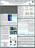
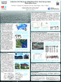
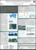
 | Teferle, F. N., Hunegnaw, A., Hibbert, A., Williams, S. D. P., Woodworth, P. L., Dalziel, I., Smalley, R. J., & Lawver, L. (16 December 2020). Vertical Land Movements and Sea Level Changes on South Georgia, South Atlantic Ocean: Results from 7 Years of Geodetic and Oceanographic Observations on a Remote Island [Paper presentation]. AGU Fall Meeting, Online Everywhere, United States. |
Erkihune, E. N., Teferle, F. N., Hunegnaw, A., & Dousa, J. (11 December 2020). Test [Poster presentation]. AGU Fall Meeting, Online Everywhere, United States. |
 | Erkihune, E. N., Teferle, F. N., Hunegnaw, A., & Dousa, J. (11 December 2020). Cross-Evaluation of Surface Meteorological Data and GNSS-derived Water Vapor with Re-analysis Information for South Georgia Island, South Atlantic Ocean [Poster presentation]. AGU Fall Meeting, Virtual Everywhere, United States. |
 | Akbarieh, A., Carbone, W., Schäfer, M., Waldmann, D., & Teferle, F. N. (09 December 2020). Extended Producer Responsibility in the Construction Sector through Blockchain, BIM and Smart Contract Technologies [Poster presentation]. The World Congress on Sustainable Technologies (WCST-2020), Virtual, United Kingdom. |
 | Zilian, A., Waldmann, D., Hertweck, F., Teferle, F. N., Schäfer, M., & Scholzen, F. (16 October 2020). Eco-construction for sustainable development (Econ4SD) – Konzepte für Materialbanken [Paper presentation]. 24. Dresdner Baustatik-Seminar, Dresden, Germany. |
 | Zilian, A., Waldmann, D., Hertweck, F., Teferle, F. N., Schäfer, M., & Scholzen, F. (2020). Eco-construction for sustainable development (Econ4SD) – Konzepte für Materialbanken. In M. Kaliske (Ed.), 24. Dresdner Baustatik-Seminar: Reality - Modeling - Structural Design (pp. 21). Peer reviewed |
 | Akbarieh, A., & Teferle, F. N. (23 September 2020). Building Information Modelling (BIM) for End-of-Lifecycle in Building Stock 4.0 [Poster presentation]. Advanced Construction and Architecture 2020 – Raw Materials and Circular Economy in the Built Environment. |
  | Backes, D., & Teferle, F. N. (2020). Multiscale Integration of High-Resolution Spaceborne and Drone-Based Imagery for a High-Accuracy Digital Elevation Model Over Tristan da Cunha. Frontiers in Earth Science. doi:10.3389/feart.2020.00319 Peer Reviewed verified by ORBi |
 | Akbarieh, A., Jayasinghe, L. B., Waldmann, D., & Teferle, F. N. (28 March 2020). BIM-Based End-of-Lifecycle Decision Making and Digital Deconstruction: Literature Review. Sustainability, 12 (7), 2670. doi:10.3390/su12072670 Peer reviewed |
 | Monteiro, C., Hunegnaw, A., & Teferle, F. N. (25 February 2020). Low-cost GNSS for Meteorology: A receiver comparison [Poster presentation]. Improving GNSS & SAR Tropospheric Products for Meteorology, Luxembourg, Luxembourg. |
 | Olivares Pulido, G., Teferle, F. N., & Hunegnaw, A. (2020). Markov Chain Monte Carlo and the Application to Geodetic Time Series Analysis. In J.-P. Montillet & M. Bos, Geodetic Time Series Analysis in Earth Sciences (1st ed, pp. 53-138). Springer. doi:10.1007/978-3-030-21718-1_3 |
 | Ejigu, Y. G., Teferle, F. N., klos, A., Bogusz, J., & Hunegnaw, A. (2020). Tracking Hurricanes using GPS atmospheric precipitable water vapor field. In Beyond 100: The Next Century in Geodesy. Heidelberg, Germany: Springer. Peer reviewed |
 | Teferle, F. N., Hunegnaw, A., Hibbert, A., Williams, S., Woodworth, P., Dalziel, I., Smalley, R. J., & Lawver, L. (13 December 2019). Consolidating Observation of Land and Sea Level Changes around South Georgia Island [Poster presentation]. AGU Fall Meeting 2019, San Francisco, United States. |
 | Bogusz, J., Hunegnaw, A., Teferle, F. N., & Klos, A. (13 December 2019). Using the Vertical Land Movement estimates from the IGS TIGA combined solution to derive Global Mean Sea Level changes [Paper presentation]. AGU Fall Meeting 2019, San Francisco, United States. |
 | Backes, D., Schumann, G., & Teferle, F. N. (11 December 2019). Conventional EO Satellites vs. CubeSats; FDL - AI flood detection onboard a Nano Satellite [Paper presentation]. 30th International Conference and AGM, Geological Remote Sensing Group (GRSG), Rome, Italy. |
 | Ejigu, Y. G., Teferle, F. N., Hunegnaw, A., Klos, A., & Bogusz, J. (10 December 2019). Tracking hurricanes Harvey and Irma using GPS tropospheric products [Poster presentation]. AGU Fall Meeting, San Francisco, United States. |
 | Teferle, F. N. (05 December 2019). Rezente geodätische Akvtitäten im Südatlantik: GNSS und Pegelinstallationen auf Südgeorgien und Tristan da Cunha [Paper presentation]. Guest Lecture, Aachen, Germany. |
 | Backes, D., Hassani, S. A., Teferle, F. N., & Schumann, G. (11 September 2019). A comparison between conventional Earth Observation Satellites and CubeSats; Requirements, Capabilities and Data Quality [Paper presentation]. 11th European CubeSat Symposium, Belval, Luxembourg. |
 | Teferle, F. N. (07 August 2019). On Recent Activities at GNSS@TG Stations in the South Atlantic Ocean and the Tracking of Hurricanes Using GNSS [Paper presentation]. Guest Lecture by Prof Felix Norman Teferle, Cape Town, South Africa. |
 | Teferle, F. N., Dalziel, I. W. D., Hunegnaw, A., Hibbert, A., Williams, S. D. P., Woodworth, P. L., Smalley, R. J., & Lawver. (25 July 2019). Present-Day Land and Sea Level Changes around South Georgia Island: Results from Precise Levelling, GNSS, Tide Gauge and Satellite Altimetry Measurements [Paper presentation]. 13th International Symposium on Antarctic Earth Science (ISAES), Incheon, South Korea. |
 | Teferle, F. N., Hunegnaw, A., Backes, D., Hibbert, A., Williams, S. D. P., Woodworth, P. L., & Pugh, J. P. (11 July 2019). Recent Activities on Tristan da Cunha Island: Geodetic Installations, Local Tie Measurements and their Analysis [Paper presentation]. 27th IUGG General Assembly, Montréal, Canada. |
 | Backes, D., Schumann, G., Teferle, F. N., & Boehm, J. (June 2019). Towards a high-resolution drone-based 3D mapping dataset to optimise flood hazard modelling. International Archives of the Photogrammetry, Remote Sensing and Spatial Information Sciences, XLII-2/W13, 181-187. doi:10.5194/isprs-archives-XLII-2-W13-181-2019 Peer Reviewed verified by ORBi |
 | Carr, C., König, A., Reckinger, R., Schulz, C., Siebentritt, S., & Teferle, F. N. (2019). "Keine Schwarzseher" Forscher der Universität Luxemburg unterstützen Jugendliche von "Fridays for Future". Luxemburger Wort, p. 12. |
Backes, D., & Teferle, F. N. (09 April 2019). Integration of high-resolution space-borne and terrestrial topographic data sets - Case study Tristan da Cunha [Poster presentation]. European Geoscience Union General Assembly 2019, Vienna, Austria. |
 | Ejigu, Y. G., Teferle, F. N., klose, A., Bogusz, J., & Hunegnaw, A. (09 April 2019). Improved Monitoringand Tracking Hurricanes using GPS Atmospheric WaterVapour [Poster presentation]. EGU General Assembly, Vienna, Austria. |
 | Erdenebat, D., Waldmann, D., & Teferle, F. N. (15 February 2019). Curvature based DAD-method for damage localisation under consideration of measurement noise minimisation. Engineering Structures, 181, 293-309. doi:10.1016/j.engstruct.2018.12.017 Peer reviewed |
 | Teferle, F. N. (2019). Über Moderne Geodatenerfassung sowie deren Anwendungen im Ingenieurwesen und in der Informations-/Technologiegesellschaft [Paper presentation]. Vortragszyklus in Zusammenarbeit mit Uni.lu, Remerschen, Luxembourg. |
| Ejigu, Y. G., Hunegnaw, A., Abraha, K. E., & Teferle, F. N. (January 2019). Impact of GPS Antenna Phase Center Models on Zenith Wet Delay and Tropospheric Gradients. GPS Solutions, 23 (5). doi:10.1007/s10291-018-0796-9 Peer Reviewed verified by ORBi |
Backes, D., & Teferle, F. N. (12 December 2018). Merging DEMs from VHR Optical Imagery with Drone Data - A High-resolution DEM for Tristan da Cunha [Paper presentation]. GRSG 2018 Annual Conference, London, United Kingdom. |
 | Erdenebat, D., Waldmann, D., & Teferle, F. N. (October 2018). Static load deflection experiment on a beam for damage detection using the Deformation Area Difference Method [Paper presentation]. The Sixth International Symposium on Life-Cycle Civil Engineering, Ghent, Belgium. |
 | Akbarieh, A., & Teferle, F. N. (26 September 2018). Building Information Modeling (BIM) in Eco-Construction and Sustainable Development [Poster presentation]. World Green Building Week, Luxembourg. doi:10.13140/RG.2.2.36763.31520 |
 | Abraha, K. E., Teferle, F. N., Hunegnaw, A., & Dach, R. (23 June 2018). Effect of unmodelled tidal displacements in GPS and GLONASS coordinate time series. Geophysical Journal International, 214 (3), 2195-2206. doi:10.1093/gji/ggy254 Peer Reviewed verified by ORBi |
 | Backes, D., Teferle, F. N., Abraha, K. E., & Bruyère, C. (10 April 2018). Towards multiscale data fusion of high-resolution space borne and terrestrial datasets over Tristan da Cunha [Poster presentation]. European Geoscience Union General Assembly 2018, Vienna, Austria. |
 | Teferle, F. N., Hunegnaw, A., Abraha, K. E., Woodworth, P., Williams, S., Hibbert, A., Smalley, R., Dalziel, I., & Lawver, L. (09 April 2018). Vertical Land Movements and Sea Level Changes around South Georgia Island [Poster presentation]. European Geosciences Union General Assembly 2018, Vienna, Austria. |
 | Klos, A., Hunegnaw, A., Teferle, F. N., Abraha, K. E., Ahmed, F., & Bogusz, J. (2018). Statistical significance of trends in Zenith Wet Delay from re-processed GPS solutions. GPS Solutions. doi:10.1007/s10291-018-0717-y Peer Reviewed verified by ORBi |
 | Erdenebat, D., Waldmann, D., Scherbaum, F., & Teferle, F. N. (15 January 2018). The Deformation Area Difference (DAD) method for condition assessment of reinforced structures. Engineering Structures, 155, 315-329. doi:10.1016/j.engstruct.2017.11.034 Peer reviewed |
 | Ding, W., Tan, B., Chen, Y., Teferle, F. N., & Yuan, Y. (2018). Evaluation of a regional real-time precise positioning system based on GPS/BeiDou observations in Australia. Advances in Space Research. doi:10.1016/j.asr.2017.11.009 Peer reviewed |
 | Teferle, F. N., Hunegnaw, A., Abraha, K. E., Woodworth, P., Williams, S., Hibbert, A., Smalley, R., Dalziel, I., & Lawver, L. (11 December 2017). First Vertical Land Movement Estimates on South Georgia Island: An Impact Study on Sea Level Change from Tide Gauge and Altimetry Measurements [Poster presentation]. American Geophysical Union Fall Meeting 2017, New Orleans, 10-15 December 2017, United States. |
 | Klos, A., Olivares Pulido, G., Teferle, F. N., Hunegnaw, A., & Bogusz, J. (2017). On the combined effect of periodic signals and colored noise on velocity uncertainties. GPS Solutions. doi:10.1007/s10291-017-0674-x Peer Reviewed verified by ORBi |
 | Teferle, F. N. (2017). Sea Level Changes, Monitoring of Vertical Land Movements and TIGA Activities. |
 | Teferle, F. N. (2017). Global Navigation Satellite System (GNSS) at Tide Gauge Installations in the South Atlantic Ocean. |
 | Erdenebat, D., Waldmann, D., & Teferle, F. N. (2017). Laboratory experiment for damage assessment using the DAD-method. In Conference proceedings SMAR 2017 (4th ed). Switzerland: Empa. Peer reviewed |
 | Hunegnaw, A., Teferle, F. N., Abraha, K. E., Bingley, R., Hansen, D., Deng, Z., Schöne, T., Santamaria-Gomez, A., Gravelle, M., Wöppelmann, G., Sanchez, L., Moore, M., & Jia, M. (13 July 2017). A Global Vertical Land Movement Data Set from a Combination of Global Navigation Satellite System Solutions [Poster presentation]. International WCRP/IOC Conference 2017 Regional Sea Level Changes and Coastal Impacts, New York, United States. |
 | Hunegnaw, A., Teferle, F. N., Abraha, K. E., Santamaria-Gomez, A., Gravelle, M., Wöppelmann, G., Schöne, T., Deng, Z., Bingley, R., Hansen, D., Sanchez, L., & Moore, M. (03 July 2017). On the Scientific Applications of IGS Products: An Assessment of the Reprocessed TIGA Solutions and Combined Products [Paper presentation]. IGS Workshop 2017, Pathways to Improved Precision, Paris, France. |
 | Ahmed, F., Hunegnaw, A., Teferle, F. N., & Bingley, R. (27 April 2017). Evaluation of ERA-Interim for tropospheric delay and water vapour estimation in different climate zones using ground-based GNSS observations [Poster presentation]. European Geoscience Union General Assembly 2017, Vienne, Austria. |
 | Hunegnaw, A., Teferle, F. N., & Abraha, K. E. (23 April 2017). A New Global Vertical Land Movement Data Set from the TIGA Combined [Poster presentation]. European Geosciences Union General Assembly, Vienna, Austria. |
 | Klos, A., Hunegnaw, A., Teferle, F. N., Abraha, K. E., Ahmed, F., & Bogusz, J. (22 February 2017). Noise characteristics in Zenith Total Delay from homogeneously reprocessed GPS time series [Paper presentation]. COST Action ES1206 GNSS4SWEC Final Workshop, Noordwijk, Netherlands. |
 | Ding, W., Teferle, F. N., Kazmierski, K., Laurichesse, D., & Yuan, Y. (21 February 2017). An Evaluaton of Real-Time Troposphere Products Based on mult-GNSS Precise Point Posi)oning [Paper presentation]. COST Action ES1206 GNSS4SWEC Final Workshop, Noordwijk, Netherlands. |
 | Ding, W., Teferle, F. N., Kazmierski, K., Laurichesse, D., & Yuan, Y. (2017). An evaluation of real-time troposphere estimation based on GNSS Precise Point Positioning. Journal of Geophysical Research. Atmospheres, 122 (5), 2779--2790. doi:10.1002/2016JD025727 Peer Reviewed verified by ORBi |
 | Hadas, T., Teferle, F. N., Kazmierski, K., Hordyniec, P., & Bosy, J. (2016). Optimum stochastic modeling for GNSS tropospheric delay estimation in real-time. GPS Solutions, 1--13. doi:10.1007/s10291-016-0595-0 Peer Reviewed verified by ORBi |
 | Hunegnaw, A., Teferle, F. N., Abraha, K. E., Bingley, R., & Hansen, D. (12 December 2016). Error analysis of Tide Gauge Benchmark Monitoring (TIGA) Analysis Center stacked solutions [Poster presentation]. AGU Fall Meeting 2016, San Francisco, CA, USA, 12-16 December, San Francisco, United States. |
 | Abraha, K. E., Teferle, F. N., Hunegnaw, A., & Dach, R. (12 December 2016). On the Impact of Multi-GNSS Solutions on Satellite Products and Positioning [Poster presentation]. American Geophysical Union (AGU) Fall Meeting 2016, San Francisco, United States. |
 | Abraha, K. E., Teferle, F. N., Hunegnaw, A., & Dach, R. (2016). GNSS related periodic signals in coordinate time-series from Precise Point Positioning. Geophysical Journal International. doi:10.1093/gji/ggw467 Peer Reviewed verified by ORBi |
 | Erdenebat, D., Waldmann, D., & Teferle, F. N. (2016). Numerical investigation of bridges with the aim of condition assessment in applying the Deformation Area Difference method (DAD-method) and selecting appropriate measurement techniques. In 5th International Symposium on Life-Cycle Civil Engineering (IALCCE 2016), Delft. Peer reviewed |
 | Hunegnaw, A., Klos, A., Hansen, D., Teferle, F. N., Abraha, K. E., Bingley, R., & Bogusz, J. (30 July 2016). A New Vertical Land Movements Data Set from a Reprocessing of GNSS at Tide Gauge Stations [Paper presentation]. IAG/CPGPS International Conference on GNSS+ (ICG+ 2016) Advances, Opportunities and Challenges, Shanghai, China. |
 | Teferle, F. N., Ding, W., Abraha, K. E., Hunegnaw, A., Laurichesse, D., Dach, R., Kazmierski, K., & Yunbin, Y. (30 July 2016). Multi-GNSS Benefits to Real-Time and Long-Term Monitoring Applications [Paper presentation]. IAG/CPGPS International Conference on GNSS+ (ICG+ 2016) Advances, Opportunities and Challenges, Shanghai, China. |
 | Klos, A., Teferle, F. N., Hunegnaw, A., Ahmed, F., Abraha, K. E., & Bogusz, J. (29 July 2016). On the Properties of Zenith Total Delay Time Series from Reprocessed GPS Solutions [Poster presentation]. IAG/CPGPS International Conference on GNSS+ (ICG+ 2016) - Advances, Opportunities and Challenges, Shanghai, China. |
 | Abraha, K. E., Teferle, F. N., Hunegnaw, A., & Dach, R. (2016). Impact of Limited Satellite Visibility on Estimates of Vertical Land Movements. International Association of Geodesy Symposia, 1-8. doi:10.1007/1345_2016_231 Peer Reviewed verified by ORBi |
 | Klos, A., Hunegnaw, A., Bos, M., Teferle, F. N., Fernandes, R., & Bogusz, J. (June 2016). Accessing of Post-SPeoiswmeirc-LDaewfoPrrmoapteiortnies in Land Movements [Paper presentation]. 18th International Symposium on Geodynamics and Earth Tides, Trieste, Italy. |
 | Hunegnaw, A., Teferle, F. N., Bingley, R., & Hansen, D. (May 2016). Status of TIGA activities at the British Isles continuous GNSS Facility and the University of Luxembourg. International Association of Geodesy Symposia, 143, 617-623. doi:10.1007/1345_2015_77 Peer Reviewed verified by ORBi |
 | Hunegnaw, A., & Teferle, F. N. (19 April 2016). Combination of Tide Gauge Benchmark Monitoring (TIGA) Analysis Center from repro2 solutions [Poster presentation]. EGU General Assembly 2016, Austria. |
 | Klos, A., Olivares Pulido, G., Teferle, F. N., Hunegnaw, A., & Bogusz, J. (05 April 2016). The Combined Effect of Periodic Signals and Noise on the Dilution of Precision of GNSS Station Velocity Uncertainties [Poster presentation]. EGU General Assembly 2015, Vienna, Austria, 17-22 April 2016, Vienna, Austria. |
 | Teferle, F. N., Combrinck, L., Botha, R., Hunegnaw, A., Abraha, K. E., & Ding, W. (11 February 2016). A First Evaluation of the new GNSS Station Installations at the Tide Gauges of Walvis Bay and Lüderitz in the Republic of Namibia [Poster presentation]. IGS Workshop 2016, Sydney, Australia. |
 | Klos, A., Olivares, G., Teferle, F. N., Bogusz, J., & Hunegnaw, A. (05 February 2016). Total Impact of Periodic Terms and Coloured Noise on Velocity Estimates [Poster presentation]. IGS Workshop, Sydney, Australia. |
 | Hunegnaw, A., & Teferle, F. N. (February 2016). Quality assessment of Mulit-Year BLT Tide Gauge Benchmark Monitoring (TIGA) repro2 Solution [Poster presentation]. IGS2016 Workshop, Sydney, Australia. |
 | Sidorov, D., & Teferle, F. N. (2016). Impact of Antenna Phase Centre Calibrations on Position Time Series: Preliminary Results. In P. Willis & C. Rizos (Eds.), IAG 150 Years Proceedings of the 2013 IAG Scientific Assembly, Postdam,Germany, 1–6 September, 2013 (pp. 117-123). Heidelberg, Germany: Springer. doi:10.1007/1345_2015_216 Peer reviewed |
 | Ahmed, F., Teferle, F. N., Bingley, R., & Laurichesse, D. (2016). The Status of GNSS Data Processing Systems to Estimate Integrated Water Vapour for Use in Numerical Weather Prediction Models. In P. Willis & C. Rizos (Eds.), IAG 150 Years Proceedings of the 2013 IAG Scientific Assembly, Postdam,Germany, 1–6 September, 2013 (pp. 587-593). Springer. doi:10.1007/1345_2015_178 Peer reviewed |
 | Teferle, F. N., Hunegnaw, A., Ahmed, F., Sidorov, D., Woodworth, P. L., Foden, P. R., & Williams, S. P. D. (2016). The King Edward Point Geodetic Observatory, South Georgia, South Atlantic Ocean: A First Evaluation and Potential Contributions to Geosciences. In P. Willis & C. Rizos (Eds.), IAG 150 Years Proceedings of the 2013 IAG Scientific Assembly, Postdam, Germany, 1–6 September, 2013 (pp. 625-630). Heidelberg, Germany: Springer. doi:10.1007/1345_2015_175 Peer reviewed |
 | Hunegnaw, A., & Teferle, F. N. (17 December 2015). Assessment of BLT Tide Gauge Benchmark Monitoring (TIGA) repro2 Solutions [Poster presentation]. AGU Fall Meeting 2015, San Francisco, CA, USA, 14-18 December, San Francisco, United States. |
 | Abraha, K. E., Teferle, F. N., Hunegnaw, A., & Dach, R. (27 October 2015). Signal Obstructions at GNSS Stations: Benefits From Multi-GNSS Observations [Poster presentation]. 5th International Colloquium on Scientific and Fundamental Aspects of the Galileo Programme, Braunschweig, Germany. |
 | Ding, W., Ahmed, F., Teferle, F. N., Laurichesse, D., & Abraha, K. E. (October 2015). An evaluation of multi-GNSS zenith tropospheric delay products based on real-time satellite products [Poster presentation]. 5th Galileo Science Colloquium. |
 | Abraha, K. E., Teferle, F. N., Hunegnaw, A., & Dach, R. (27 June 2015). Impact of Limited Multi-GNSS Visibility on Vertical Land Movement Estimates [Poster presentation]. 26th General Assembly of the International Union of Geodesy and Geophysics (IUGG), Prague, Czechia. |
 | Teferle, F. N., Hunegnaw, A., Woodworth, P. L., Foden, P. R., Williams, S. D. P., Pugh, J., & Hibbert, A. (27 June 2015). Calibration of the Tide Gauge at King Edward Point, South Georgia Island, South Atlantic Ocean [Poster presentation]. 26th General Assembly of the International Union of Geodesy and Geophysics (IUGG), Prague, Czechia. |
 | Ahmed, F., Hunegnaw, A., Teferle, F. N., & Bingley, R. (26 June 2015). Analysis of Global Climate Variability from Homogenously Reprocessed Ground-based GNSS Measurements [Poster presentation]. 26th IUGG General Assembly, Prague, Czechia. |
Teferle, F. N., Hunegnaw, A., Woodworth, P. L., Foden, P. R., Williams, S. D. P., Pugh, J., & Hibbert, A. (12 June 2015). A New Datum-Controlled Tide Gauge Record for Sea Level Studies in the South Atlantic Ocean: King Edward Point, South Georgia Island [Poster presentation]. Global and Regional Sea Level Variability and Change, Palma de Mallorca, Spain. |
 | Simeonov, T., Sidorov, D., Teferle, F. N., Guerova, G., Egova, E., Vassileva, K., & Milev, G. (20 May 2015). Sofia University GNSS Analysis Center (SUGAC) [Paper presentation]. FIG Working Week 2015, Sofia, Bulgaria. |
 | Ahmed, F., Hunegnaw, A., Teferle, F. N., & Bingley, R. (14 April 2015). Analysis of global climate variability from homogenously reprocessed ground-based GNSS measurements [Paper presentation]. European Geosciences Union General Assembly 2015, Vienna, Austria. |
 | Hunegnaw, A., & Teferle, F. N. (12 April 2015). A Multi-Year Combination of Tide Gauge Benchmark Monitoring (TIGA) Analysis Center Products [Poster presentation]. EGU General Assembly 2015, Vienna, Austria, 12-17 April 2015, Vienna, Austria. |
 | Teferle, F. N., Hunegnaw, A., Woodworth, P. L., Foden, P. R., Williams, S. D. P., Hibbert, A., & Pugh, J. (12 March 2015). Calibration of the Tide Gauge at King Edward Point, South Georgia Island [Poster presentation]. UK Sea Level Science Meeting, Liverpool, United Kingdom. |
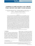 | Mahfouf, J.-F., Ahmed, F., Moll, P., & Teferle, F. N. (2015). Assimilation of zenith total delays in the AROME France convective scale model: a recent assessment. Tellus. Series A. doi:10.3402/tellusa.v67.26106 Peer reviewed |
Hunegnaw, A., & Teferle, F. N. (2015). Assessment of BLT Tide Gauge Benchmark Monitoring (TIGA) repro2 solutions [Poster presentation]. AGU Fall Meeting 2015, San Francisco, CA, USA, 14-18 December. |
 | Ahmed, F., Hunegnaw, A., Teferle, F. N., & Bingley, R. (17 December 2014). An analysis of global climate variability from homogeneously reprocessed GNSS measurements [Poster presentation]. American Geophysical Union Fall Meeting 2014, San Francisco, United States. |
 | Hunegnaw, A., Teferle, F. N., Bingley, R., & Hansen, D. (16 December 2014). A Multi-Year Combination of Tide Gauge Benchmark Monitoring (TIGA) Analysis Center Products: Preliminary results [Poster presentation]. AGU Fall Meeting 2014, San Francisco, CA, USA, 15-19 December. |
 | Ahmed, F., Vaclavovic, P., Teferle, F. N., Dousa, J., Bingley, R., & Laurichesse, D. (2014). Comparative Analysis of Real-Time Precise Point Positioning Zenith Total Delay Estimates. GPS Solutions. doi:10.1007/s10291-014-0427-z Peer Reviewed verified by ORBi |
 | Sidorov, D., & Teferle, F. N. (14 October 2014). Impact of Station GNSS Antenna Phase Centre Calibrations on Satellite Orbits and Station Coordinates: Preliminary Results [Poster presentation]. IAG Commission 1 Symposium 2014: Reference Frames for Applications in Geosciences (REFAG2014). |
 | Smalley, R. J., Bevis, M. G., Zakrajsek, A. F., Teferle, F. N., Dalziel, I. W. D., Lawver, L. A., & Larter, R. D. (September 2014). Near Field Dynamic, Co-seismic and Post-seismic Deformations Associated with the 2013, M7.8, and 2003, M7.6, South Scotia Ridge Earthquakes Observed with GPS [Poster presentation]. XXXIII SCAR Biennial Meetings Including the 2014 Open Science Conference, Auckland, New Zealand. |
 | Ye, L., Lay, T., Koper, K. D., Smalley, R. J., Rivera, L., Bevis, M. G., Zakrajsek, A. F., & Teferle, F. N. (01 September 2014). Complementary slip distribution of the August 4, 2003 Mw 7.6 and November 17, 2013 Mw 7.8 South Scotia Ridge earthquakes. Earth and Planetary Science Letters, 401, 215-226. doi:10.1016/j.epsl.2014.06.007 Peer reviewed |
 | Teferle, F. N., Hunegnaw, A., Williams, S., Foden, P., & Woodworth, P. (26 July 2014). Recent Activities at the King Edward Point Geodetic Observatory, South Georgia, in Support of TIGA Objectives [Poster presentation]. IGS Workshop 2014: Celebrating 20 Years of Service 1994-2014, Pasadena, United States. |
 | Simeonov, T., Sidorov, D., Teferle, F. N., Guerova, G., Egova, E., Vasileva, K., Milev, I., & Milev, G. (25 June 2014). SUGAC: Sofia University GNSS Analysis Center [Poster presentation]. IGS Workshop 2014: Celebrating 20 Years of Service 1994 - 2014, Pasadena, United States. |
 | Mahfouf, J.-F., Ahmed, F., Moll, P., Teferle, F. N., & Bingley, R. (February 2014). Assimilation of zenith total delays in the AROME France convective scale model: a recent assessment [Poster presentation]. Workshop ES1206 – GNSS4SWEC, Munich, Germany. |
 | Aldiss, D., Burke, H., Chacksfield, B., Bingley, R., Teferle, F. N., Williams, S., Blackman, D., Burren, R., & Press, N. (January 2014). Geological interpretation of current subsidence and uplift in the London area, UK, as shown by high precision satellite-based surveying. Proceedings of the Geologists' Association, 125 (1), 1-13. doi:10.1016/j.pgeola.2013.07.003 Peer reviewed |
 | Hostache, R., Matgen, P., Giustarini, L., Teferle, F. N., Tailliez, C., Iffly, J.-F., & Corato, G. (2014). A drifting GPS buoy for retrieving effective riverbed bathymetry. Journal of Hydrology, (0). doi:10.1016/j.jhydrol.2014.11.018 Peer Reviewed verified by ORBi |
 | Ahmed, F., Vaclavovic, P., Teferle, F. N., Dousa, J., Bingley, R., & Laurichesse, D. (13 December 2013). Comparative Analysis of Real-Time Precise Point Positioning Zenith Total Delay Estimates [Poster presentation]. American Geophysical Union Fall Meeting 2013, San Francisco, United States. |
 | Olivares Pulido, G., & Teferle, F. N. (10 December 2013). A Comparison of Bayesian Monte Carlo Markov Chain and Maximum Likelihood Estimation Methods for the Statistical Analysis of Geodetic Time Series [Paper presentation]. American Geophysical Union Fall Meeting 2013, San Francisco, United States. |
 | Teferle, F. N., Hunegnaw, A., Ahmed, F., Woodworth, P. L., Foden, P. R., & Williams, S. D. P. (28 October 2013). The King Edward Point Geodetic Observatory in Support of Sea Level Research [Poster presentation]. PSMSL 80th Anniversary Workshop on Sea Level Science, Liverpool, United Kingdom. |
 | Olivares Pulido, G., & Teferle, F. N. (06 September 2013). A Bayesian Monte Carlo Markov Chain Method for the Statistical Analysis of Geodetic Time Series [Poster presentation]. International Association of Geodesy. |
 | Ahmed, F., Teferle, F. N., Bingley, R., & Laurichesse, D. (September 2013). Assessing the Status of GNSS Data Processing Systems to Estimate Integrated Water Vapour for Use in Numerical Weather Prediction models [Poster presentation]. IAG Scientific Assembly 2013, IAG 150 Years, Potsdam, Germany, September 1-6, 2013, Potsdam, Germany. |
 | Sidorov, D., & Teferle, F. N. (01 September 2013). Antenna phase centre calibration effects on position time-series: preliminary results [Poster presentation]. IAG Scientific Assembly 2013: IAG 150 Years, Potsdam, Germany. |
 | Teferle, F. N., Hunegnaw, A., Ahmed, F., Sidorov, D., Williams, S., Foden, P., & Woodworth, P. (01 September 2013). Potential Contributions to Geoscience from GNSS Observations of the King Edward Point Geodetic Observatory, South Georgia, South Atlantic Ocean [Poster presentation]. IAG Scientific Assembly 2013, IAG 150 Years, Potsdam, Germany. |
 | Teferle, F. N., White, S. W., Foden, P. R., Strachan, R., Whittamore, L. P., Woodworth, P. L., Williams, S. D. P., Hunegnaw, A., & Ahmed, F. (May 2013). Installation and First Evaluation of the King Edward Point Geodetic Observatory, South Georgia [Poster presentation]. The Scotia Arc: Geodynamic Evolution and Global Implications, Granada, Spain. |
 | Ahmed, F., Teferle, F. N., Bingley, R., & Laurichesse, D. (12 April 2013). An Evaluation of the Accuracy of Real-Time Zenith Total Delay Estimates [Paper presentation]. European Geosciences Union General Assembly 2013, Vienna, Austria. |
 | Olivares Pulido, G., & Teferle, F. N. (12 April 2013). A Bayesian Monte Carlo Markov Chain Method for the Analysis of GPS Position Time Series [Poster presentation]. European Geosciences Union General Assembly 2013. |
 | Gazeaux, J., Williams, S., King, M., Bos, M., Dach, R., Deo, M., Moore, A., Ostini, L., Petrie, E., Roggero, M., Teferle, F. N., Olivares Pulido, G., & Webb, F. H. (08 March 2013). Detecting offsets in GPS time series: First results from the detection of offsets in GPS experiment. Journal of Geophysical Research. Solid Earth, 118. doi:10.1002/jgrb.50152 Peer reviewed |
 | Olivares Pulido, G., & Teferle, F. N. (2013). A Bayesian Monte Carlo Markov Chain Method for Parameter Estimation of Fractional Differenced Gaussian Processes. IEEE Transactions on Signal Processing, 61 (9), 2405-2412. doi:10.1109/TSP.2013.2245658 Peer reviewed |
 | Teferle, F. N. (2013). The King Edward Point Geodetic Observatory. Luxembourg: University of Luxembourg. |
 | Hunegnaw, A., Teferle, F. N., Bingley, R., & Hansen, D. (2013). Status of TIGA activities at the British Isles continuous GNSS Facility and the University of Luxembourg [Paper presentation]. IAG Scientific Assembly 2013, IAG 150 Years, Potsdam, Germany. |
 | Ahmed, F., Teferle, F. N., & Bingley, R. (December 2012). An Evaluation of Real-Time Zenith Total Delay Estimates [Poster presentation]. American Geophysical Union Fall Meeting 2012, San Francisco, United States. |
 | Ahmed, F., Teferle, F. N., Bingley, R., & Bareiss, J. (2012). GNSS Meteorology in Luxembourg. Cahier Scientifique - Revue Technique Luxembourgeoise, (1), 16-22. |
 | Ahmed, F., Teferle, F. N., & Bingley, R. (July 2012). An Evaluation of Real-Time, Near Real-Time and Post-Processed Zenith Total Delay Estimates [Poster presentation]. International GNSS Service Workshop 2012, Olzstyn, Poland. |
 | Ahmed, F., Teferle, F. N., & Bingley, R. (April 2012). First Zenith Total Delay and Integrated Water Vapour Estimates from the Near Real-Time GNSS Data Processing Systems at the University of Luxembourg [Poster presentation]. European Geosciences Union General Assembly 2012, Vienna, Austria. |
 | Ahmed, F., Teferle, F. N., & Bingley, R. (16 March 2012). First Zenith Total Delay and Integrated Water Vapour Estimates from the Near Real-Time GNSS Data Processing Systems at the University of Luxembourg [Poster presentation]. Luxembourg Earth Observation and Integrated Applications Day. |
 | Geng, J., Williams, S. D. P., Teferle, F. N., & Dodson, A. H. (2012). Detecting storm surge loading deformations around the southern North Sea using subdaily GPS. Geophysical Journal International, 191 (2), 569-578. doi:10.1111/j.1365-246X.2012.05656.x Peer reviewed |
 | Hansen, D., Teferle, F. N., Bingley, R. M., & Williams, S. D. P. (2012). New Estimates of Present-Day Crustal/Land Motions in the British Isles Based on the BIGF Network. International Association of Geodesy Symposia, 136, 665. doi:10.1007/978-3-642-20338-1_82 Peer Reviewed verified by ORBi |
 | Geng, J., Meng, X., Teferle, F. N., & Dodson, A. H. (2010). Performance of Precise Point Positioning with Ambiguity Resolution for 1- to 4- hour Observation Periods. Survey Review, 42 (316), 155-165. doi:10.1179/003962610X12572516251682 Peer Reviewed verified by ORBi |
 | Geng, J., Meng, X., Dodson, A. H., & Teferle, F. N. (2010). Integer ambiguity resolution in precise point poistioning: method comparison. Journal of Geodesy, 84 (9), 569-581. doi:10.1007/s00190-010-0399-x Peer reviewed |
 | Geng, J., Meng, X., Dodson, A. H., Ge, M., & Teferle, F. N. (2010). Rapid re-convergences to ambiguity-fixed solutions in precise point-positioning. Journal of Geodesy, 84 (12), 705-714. doi:10.1007/s00190-010-0404-4 Peer reviewed |
 | Geng, J., Teferle, F. N., Meng, X., & Dodson, A. H. (2010). Kinematic precise point postioning at remote marine platforms. GPS Solutions, 14 (4), 343-350. doi:10.1007/s10291-009-0157-9 Peer Reviewed verified by ORBi |
 | Geng, J., Teferle, F. N., Meng, X., & Dodson, A. H. (2010). Towards PPP-RTK: Ambiguity Resolution in Real-Time Precise Point Positioning. Advances in Space Research, 1-5. doi:10.1016/j.asr.2010.03.030 Peer reviewed |
 | Teferle, F. N., Bingley, R. M., Orliac, E. J., Williams, S. D. P., Woodworth, P., McLaughlin, D., Baker, T. F., Shennan, I., Milne, G. A., Bradley, S. L., & Hansen, D. (2009). Crustal Motions in Great-Britain: Evidence from continuous GPS, Absolute Gravity and Holocene Sea-Level Data. Geophysical Journal International, 178 (1), 23-46. doi:10.1111/j.1365-246X.2009.04185.x Peer Reviewed verified by ORBi |
 | Bradley, S. L., Milne, G. A., Teferle, F. N., Bingley, R. M., & Orliac, E. J. (2009). Glacial Isostatic Adjustment of the British Isles: New constraints form GPS measurements of crustal motion. Geophysical Journal International, 178 (178), 14-22. doi:10.1111/j.1365-246X.2008.04033.x Peer Reviewed verified by ORBi |
 | Woodworth, P., Teferle, F. N., Bingley, R. M., Shennan, I., & Williams, S. D. P. (2009). Trends in UK Mean Sea Level revisited. Geophysical Journal International, 179 (179), 19-30. doi:10.1111/j.1365-246X.2008.03942.x Peer Reviewed verified by ORBi |
 | Geng, J., Teferle, F. N., Shi, C., Meng, X., Dodson, A. H., & Liu, J. (2009). Ambiguity resolution in precise point positioning with hourly data. GPS Solutions, 13 (4), 263-270. doi:10.1007/s10291-009-0119-2 Peer Reviewed verified by ORBi |
 | Bingley, R. M., Teferle, F. N., Orliac, E. J., Dodson, A. H., Williams, S. D. P., Blackman, D. L., Baker, T. F., Riedmann, M., Haynes, M., Press, N., Aldiss, D. T., Burke, H. C., Chacksfield, B. C., Tragheim, D., Tarrant, O., Tanner, S., Reeder, T., Lavery, S., Meadowcroft, I., ... Richardson, D. (2008). Measurement of current changes in land levels as input to long-term planning for flood risk management along the Thames estuary. Journal of Flood Risk Management, 1 (3), 162--172. doi:10.1111/j.1753-318X.2008.00018.x Peer reviewed |
 | Teferle, F. N., Williams, S. D. P., Kierulf, H. P., Bingley, R. M., & Plag, H.-P. (2008). A continuous GPS coordinate time series analysis strategy for high-accuracy vertical land movements. Physics and Chemistry of the Earth, 33 (3-4), 205-216. doi:10.1016/j.pce.2006.11.002 Peer Reviewed verified by ORBi |
 | Almuslmani, B., Al-Motari, E., Bingley, R. M., Teferle, F. N., & Moore, T. (2006). A GPS Network Densification in Saudi Arabia in Support of Geophysical Investigations in the Region [Poster presentation]. American Geophysical Union Fall Meeting 2006, San Francisco, CA, United States. |
 | Bingley, R. M., Teferle, F. N., Dodson, A. H., Williams, S., & Baker, T. (2006). Measuring Changes in Ground Level at Tide Gauges using Continuous GPS and Absolute Gravimetry to Improve Estimates of Changes in Sea Level Around Britain. In Proceedings of the 41st Defra Flodd and Coastal Management Conference 2006 (pp. 4). |
 | Teferle, F. N., Williams, S., Kierulf, H., Bingley, R., & Plag, H.-P. (2005). The Effect of Processing Technique and Reference Frame Definition on Noise in CGPS Position Time Series [Poster presentation]. American Geophysical Union Fall Meeting 2005, San Francisco, CA, United States. |